Property Record
2912 Trask Pky, Beaufort, SC 29906


NEARBY LISTINGS FOR SALE OR LEASE
-
-
View all Beaufort listings for sale on LoopNet.com
Property Detail
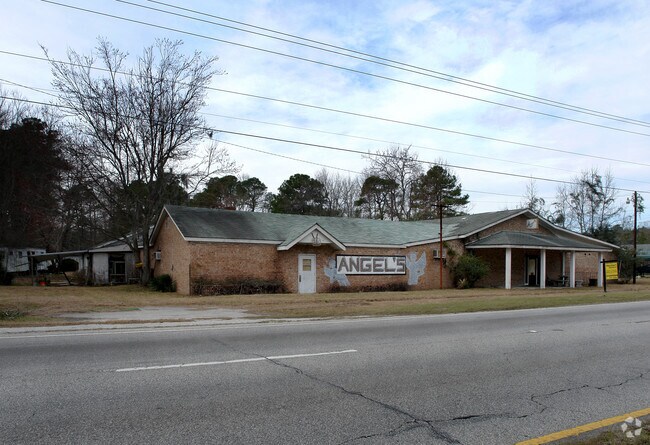
2912 Trask Pky
Hilton Head Island-Bluffton-Port Royal, SC
Us Hwy 21 N. Commercial Corrid
R100-020-000-0078-0000
ANGELS MOB HOME PARK PAR A PB108 P157 *MERGE FROM KEY #1774244
Bartavern
Beaufort
2025
South Carolina
2024
2.25 AC
000200
Hilton Head/Beaufort
6,441 SF
Other Market Areas
DEMOGRAPHICS near 2912 Trask Pky
1 Mile
3 Mile
5 Mile
2024 Total Population
1,095
8,355
24,171
2029 Population
1,209
9,035
26,534
Pop Growth 2024-2029
+ 10.41%
+ 8.14%
+ 9.78%
Average Age
37
34
37
2024 Total Households
399
2,339
8,615
HH Growth 2024-2029
+ 10.03%
+ 9.71%
+ 10.11%
Median Household Inc
$35,909
$51,535
$50,521
Avg Household Size
2.60
2.60
2.50
2024 Avg HH Vehicles
2.00
2.00
2.00
Median Home Value
$145,744
$153,816
$237,163
Median Year Built
1996
1992
1991
Nearby Places
Map Layers
Map Styles
 Street
 Aerial
- Restaurants
- Banks
- Shops
- Fitness
- Groceries
PUBLIC TRANSPORTATION
AIRPORT
Hilton Head
DRIVE
WALK
Distance
Hilton Head
52 min
39.1 mi
Savannah/Hilton Head International
DRIVE
WALK
Distance
Savannah/Hilton Head International
64 min
47.9 mi
Freight Ports
Georgia Ports - Savannah
DRIVE
WALK
Distance
Georgia Ports - Savannah
63 min
46.6 mi
Nearby Properties
Address
Land Use
TOTAL SIZE
Lot Size
Zoning
Address
Land Use
TOTAL SIZE
Lot Size
Zoning
4,613 AC
6601
Address
Land Use
TOTAL SIZE
Lot Size
Zoning
64,000 SF
5.92 AC
Address
Land Use
TOTAL SIZE
Lot Size
Zoning
85,127 SF
35.70 AC
6611
Address
Land Use
TOTAL SIZE
Lot Size
Zoning
17,432 SF
7.15 AC
6611
Address
Land Use
TOTAL SIZE
Lot Size
Zoning
124,500 SF
72.60 AC
6101
Address
Land Use
TOTAL SIZE
Lot Size
Zoning
5,990 SF
2 AC
Address
Land Use
TOTAL SIZE
Lot Size
Zoning
49,216 SF
7.06 AC
6611
Address
Land Use
TOTAL SIZE
Lot Size
Zoning
59,100 SF
5.13 AC
6611
Address
Land Use
TOTAL SIZE
Lot Size
Zoning
12,444 SF
2.59 AC
6611
Address
Land Use
TOTAL SIZE
Lot Size
Zoning
117.17 AC
9999
Address
Land Use
TOTAL SIZE
Lot Size
Zoning
16,002 SF
10.30 AC
6611
Address
Land Use
TOTAL SIZE
Lot Size
Zoning
4,302 SF
7.50 AC
6611
Address
Land Use
TOTAL SIZE
Lot Size
Zoning
34,124 SF
8.30 AC
6611
Address
Land Use
TOTAL SIZE
Lot Size
Zoning
10,040 SF
20.53 AC
6611
Address
Land Use
TOTAL SIZE
Lot Size
Zoning
10,043 SF
3 AC
Address
Land Use
TOTAL SIZE
Lot Size
Zoning
41,439 SF
27.75 AC
6611
Address
Land Use
TOTAL SIZE
Lot Size
Zoning
34,450 SF
10.07 AC
6601
Address
Land Use
TOTAL SIZE
Lot Size
Zoning
2,250 SF
1.59 AC
6611
Address
Land Use
TOTAL SIZE
Lot Size
Zoning
113 SF
16.85 AC
6611
Address
Land Use
TOTAL SIZE
Lot Size
Zoning
12,000 SF
13.88 AC
6611
Address
Land Use
TOTAL SIZE
Lot Size
Zoning
64,722 SF
14.24 AC
6611
Address
Land Use
TOTAL SIZE
Lot Size
Zoning
8,566 SF
66.43 AC
6611
Address
Land Use
TOTAL SIZE
Lot Size
Zoning
59.88 AC
Address
Land Use
TOTAL SIZE
Lot Size
Zoning
1,568 SF
64.85 AC
4211
Address
Land Use
TOTAL SIZE
Lot Size
Zoning
48,960 SF
13.29 AC
6611
Address
Land Use
TOTAL SIZE
Lot Size
Zoning
2,448 SF
6.40 AC
6611
Address
Land Use
TOTAL SIZE
Lot Size
Zoning
24,530 SF
1.34 AC
6611
Address
Land Use
TOTAL SIZE
Lot Size
Zoning
98.11 AC
6101
Address
Land Use
TOTAL SIZE
Lot Size
Zoning
5,229 SF
8.79 AC
6611
Address
Land Use
TOTAL SIZE
Lot Size
Zoning
8,000 SF
3.21 AC
6601
The World's #1 Commercial Real Estate Marketplace
Connect with us
© 2026 CoStar Group
The information above has been obtained from sources believed reliable. While we do not doubt its accuracy we have not verified it and make no guarantee, warranty or representation about it. It is your responsibility to independently confirm its accuracy and completeness. Any projections, opinions, assumptions, or estimates used are for example only and do not represent the current or future performance of the property. The value of this transaction to you depends on tax and other factors which should be evaluated by your tax, financial, and legal advisors. You and your advisors should conduct a careful, independent investigation of the property to determine to your satisfaction the suitability of the property for your needs.